 |
 |
 Microwave Remote Sensing
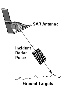
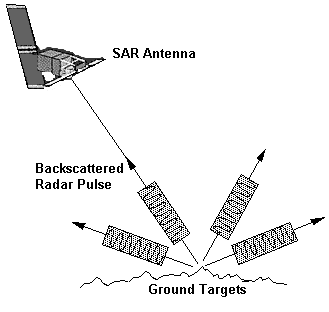
 Electromagnetic radiation in the microwave wavelength region is used in remote sensing to provide useful information about the Earth's atmosphere, land and ocean. A microwave radiometer is a passive device which records the natural microwave emission from the earth. It can be used to measure the total water content of the atmosphere within its field of view. A radar altimeter sends out pulses of microwave signals and record the signal scattered back from the earth surface. The height of the surface can be measured from the time delay of the return signals. A wind scatterometer can be used to measure wind speed and direction over the ocean surface. it sends out pulses of microwaves along several directions and records the magnitude of the signals backscattered from the ocean surface. The magnitude of the backscattered signal is related to the ocean surface roughness, which in turns is dependent on the sea surface wind condition, and hence the wind speed and direction can be derived. orne platforms to generate high resolution images of the earth surface using microwave energy. Synthetic Aperture Radar (SAR)In synthetic aperture radar (SAR) imaging, microwave pulses are transmitted by an antenna towards the earth surface. The microwave energy scattered back to the spacecraft is measured. The SAR makes use of the radar principle to form an image by utilising the time delay of the backscattered signals.
In real aperture radar imaging, the ground resolution is limited by the size of the microwave beam sent out from the antenna. Finer details on the ground can be resolved by using a narrower beam. The beam width is inversely proportional to the size of the antenna, i.e. the longer the antenna, the narrower the beam.
It is not feasible for a spacecraft to carry a very long antenna which is required for high resolution imaging of the earth surface. To overcome this limitation, SAR capitalises on the motion of the space craft to emulate a large antenna (about 4 km for the ERS SAR) from the small antenna (10 m on the ERS satellite) it actually carries on board.
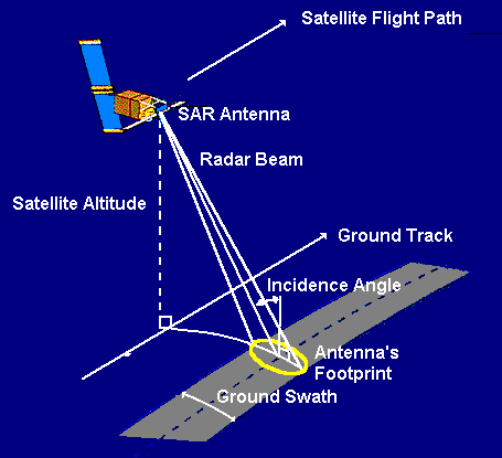 Imaging geometry for a typical strip-mapping synthetic aperture radar imaging system. The antenna's footprint sweeps out a strip parallel to the direction of the satellite's ground track.
Interaction between Microwaves and Earth's SurfaceWhen microwaves strike a surface, the proportion of energy scattered back to the sensor depends on many factors:
 Click here to read more about microwave frequency, polarisation and incident angle in SAR imaging. Click here to read more about microwave frequency, polarisation and incident angle in SAR imaging.
All-Weather ImagingDue to the cloud penetrating property of microwave, SAR is able to acquire "cloud-free" images in all weather. This is especially useful in the tropical regions which are frequently under cloud covers throughout the year. Being an active remote sensing device, it is also capable of night-time operation.

 Interpreting SAR Images Interpreting SAR Images
 Go to Main Index Go to Main Index
|