 |
 |
 Infrared Remote Sensing
 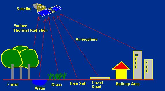 Infrared remote sensing makes use of infrared sensors to detect infrared radiation emitted from the Earth's surface. The middle-wave infrared (MWIR) and long-wave infrared (LWIR) are within the thermal infrared region. These radiations are emitted from warm objects such as the Earth's surface. They are used in satellite remote sensing for measurements of the earth's land and sea surface temperature. Thermal infrared remote sensing is also often used for detection of forest fires. Black Body Radiation
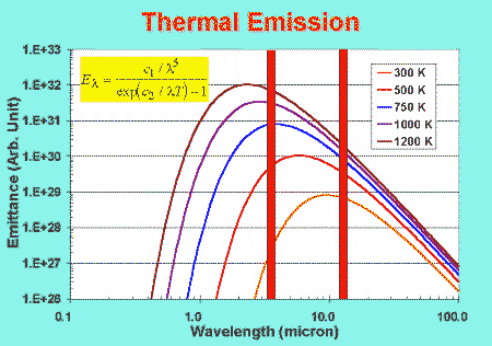
The amount of thermal radiation emitted at a particular wavelength from a warm object depends on its temperature. If the earth's surface is regarded as a blackbody emitter, its apparent temperature (known as the brightness temperature) and the spectral radiance are related by the Planck's blackbody equation, plotted in the above figure for several temperatures. For a surface at a brightness temperature around 300 K, the spectral radiance peaks at a wavelength around 10 µm. The peak wavelength decreases as the brightness temperature increases. For this reason, most satellite sensors for measurement of the earth surface temperature have a band detecting infrared radiation around 10 µm. Besides the measurement of regular surface temperature, infrared sensors can be used for detection of forest fires or other warm/hot objects. For typical fire temperatures from about 500 K (smouldering fire) to over 1000 K (flaming fire), the radiance versus wavelength curves peak at around 3.8 µm. Sensors such as the NOAA-AVHRR, ERS-ATSR and TERRA-MODIS are equipped with this band that can be used for detection of fire hot spots.
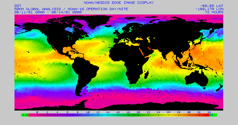 50-km resolution Global Sea Surface Temperature (SST) Field for the period 11 to 14 August 2001 derived from NOAA AVHRR thermal infrared data. Occurrence of abnormal climatic conditions such as the El-Nino can be predicted by observations of the SST anomaly, i.e. the deviation of the daily SST from the mean SST. (Credit: NOAA/NESDIS) Interpreting Optical RS Images   Microwave Remote Sensing Microwave Remote Sensing Go to Main Index Go to Main Index |