Pulau Gaya, Tunku Abdul Rahman Marine Park, Sabah, East Malaysia
21 January 2006
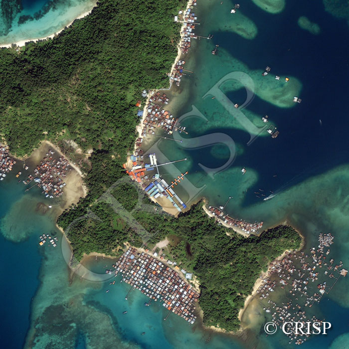
Note: The area of coverage in this IKONOS image is approximately 1.5 km x 1.5 km.
The reduced resolution image on display has undergone compression and so does not represent the true resolution of the original satellite image.
Gaya Island, part of the Tunku Abdul Rahman Marine Park, is located across a shallow strait from Kota Kinabalu. This forested hilly island with rocky headlands and sandy beaches is surrounded by coral reefs and an active marine life. Several fishing structures, boats, and a fast-approaching speedboat is seen towards the northeast of the image. An eco-resort is located on the eastern bay where the jetties stretch beyond the reefs. The other attractions are a marine ecology research centre, a beautiful sandy beach towards the north, and walking trails through primary and degraded forests. Elsewhere stilt villages, with individual houses connected by plankwalks, have been built in the sheltered bays. The village that occupies the southern bay is a densely populated example. Pulau Gaya was the first settlement of the British North Borneo Chartered Company in 1882, a place from which they were subsequently removed by local confrontation.