 |
 |
 Optical Remote Sensing
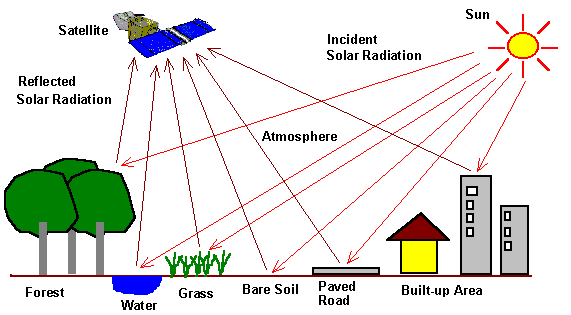 Optical remote sensing makes use of visible, near infrared and short-waveinfrared sensors to form images of the earth's surface by detecting thesolar radiation reflected from targets on the ground. Different materials reflect and absorb differently at different wavelengths. Thus, the targets can be differentiated by their spectral reflectance signatures in the remotely sensed images. Optical remote sensing systems are classified into the following types, depending on the number of spectral bands used in the imaging process.
Solar IrradiationOptical remote sensing depends on the sun as the sole source of illumination. The solar irradiation spectrum above the atmosphere can be modeled by a black body radiation spectrum having a source temperature of 5900 K, with a peak irradiation located at about 500 nm wavelength. Physical measurement of the solar irradiance has also been performed using ground based and spaceborne sensors.After passing through the atmosphere, the solar irradiation spectrum at the ground is modulated by the atmospheric transmission windows. Significant energy remains only within the wavelength range from about 0.25 to 3 µm. 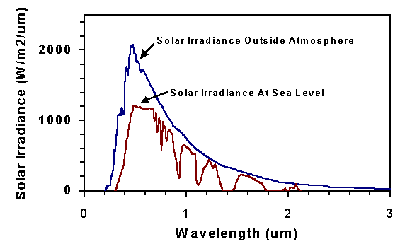 Solar Irradiation Spectra above the atmosphere and at sea-level. Spectral Reflectance SignatureWhen solar radiation hits a target surface, it may be transmitted, absorbed or reflected. Different materials reflect and absorb differently at different wavelengths. The reflectance spectrum of a material is a plot of the fraction of radiation reflected as a function of the incident wavelength and serves as a unique signature for the material. In principle, a material can be identified from its spectral reflectance signature if the sensing system has sufficient spectral resolution to distinguish its spectrum from those of other materials. This premise provides the basis for multispectral remote sensing.The following graph shows the typical reflectance spectra of five materials: clear water, turbid water, bare soil and two types of vegetation. 
Reflectance Spectrum of Five Types of Landcover The reflectance of clear water is generally low. However, the reflectance is maximum at the blue end of the spectrum and decreases as wavelength increases. Hence, clear water appears dark-bluish. Turbid water has some sediment suspension which increases the reflectance in the red end of the spectrum, accounting for its brownish appearance. The reflectance of bare soil generally depends on its composition. In the example shown, the reflectance increases monotonically with increasing wavelength. Hence, it should appear yellowish-red to the eye. Vegetation has a unique spectral signature which enables it to be distinguished readily from other types of land cover in an optical/near-infrared image. The reflectance is low in both the blue and red regions of the spectrum, due to absorption by chlorophyll for photosynthesis. It has a peak at the green region which gives rise to the green colour of vegetation. In the near infrared (NIR) region, the reflectance is much higher than that in the visible band due to the cellular structure in the leaves. Hence, vegetation can be identified by the high NIR but generally low visible reflectances. This property has been used in early reconnaisance missions during war times for "camouflage detection". The shape of the reflectance spectrum can be used for identification of vegetation type. For example, the reflectance spectra of vegetation 1 and 2 in the above figures can be distinguished although they exhibit the generally characteristics of high NIR but low visible reflectances. Vegetation 1 has higher reflectance in the visible region but lower reflectance in the NIR region. For the same vegetation type, the reflectance spectrum also depends on other factors such as the leaf moisture content and health of the plants. The reflectance of vegetation in the SWIR region (e.g. band 5 of Landsat TM and band 4 of SPOT 4 sensors) is more varied, depending on the types of plants and the plant's water content. Water has strong absorption bands around 1.45, 1.95 and 2.50 µm. Outside these absorption bands in the SWIR region, reflectance of leaves generally increases when leaf liquid water content decreases. This property can be used for identifying tree types and plant conditions from remote sensing images. The SWIR band can be used in detecting plant drought stress and delineating burnt areas and fire-affected vegetation. The SWIR band is also sensitive to the thermal radiation emitted by intense fires, and hence can be used to detect active fires, especially during night-time when the background interference from SWIR in reflected sunlight is absent. 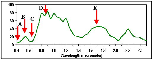 Typical Reflectance Spectrum of Vegetation. The labelled arrows indicate the common wavelength bands used in optical remote sensing of vegetation: A: blue band, B: green band; C: red band; D: near IR band; E: short-wave IR band Digital Image 
 Interpreting Optical RS Images Interpreting Optical RS Images Go to
Main Index Go to
Main Index |