 |
 |
 SPOT (Satellite Pour l'Observation de la Terre), France
  The SPOT program consists of a series of optical remote sensing satellites with the primary mission of obtaining Earth imagery for landuse, agriculture, forestry, geology, cartography, regional planning, water resources and GIS applications. it is committed to commercial remote sensing on an international scale and has established a global network of control centres, receiving stations, processing centres and data distributors. The SPOT satellites are operated by the French Space Agency, Centre National d'Etudes Spatiales (CNES). Worldwide commercial operations are anchored by SPOT IMAGE in France with the following subsidiaries: SPOT Image Corp. in the US, SPOT Imaging Services in Australia and SPOT Asia in Singapore. SPOT 1 was launched on 22 February 1986, and withdrawn from active service on 31 December 1990. SPOT 2 was launched on 22 January 1990 and is still operational. SPOT 3 was launched on 26 September 1993. An incident occured on SPOT 3 on November 14, 1996. After 3 years in orbit the satellite has stopped functioning. SPOT 4 was launched on 24 Mar 1998. Engineering work for SPOT 5 has began so that the satellite can be launched in 2002 to ensure service continuity. To meet the increasing demand for SPOT imagery, notably during the northern hemisphere growing season, SPOT 1 is reactivated in 1997 for routine operation. Currently, three SPOT satellites (SPOT 1, 2, 4) are operational. The SPOT system provides global coverage between 87 degrees north latitude and 87 degrees south latitude.
SPOT Orbit
SensorsHRV (High Resolution Visible) and HRVIR (High Resolution Visible IR) detectors
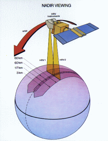
SPOT 1, 2 Twin HRV (SPOT 4 Twin HRVIR) Imaging System Each SPOT 1 and SPOT 2 satellite carries two HRV sensors, constructed with multilinear array detectors, operating in a cross-track direction. The SPOT 4 satellite carries two HRVIR detectors. The HRVIR is similar to the HRV, except that HRVIR has an additional short wave infrared (SWIR) band, and the wavelength bandwidth of the panchromatic mode for HRVIR is narrower than that for HRV. The position of each HRV or HRVIR entrance mirror can be commanded by ground control to observe a region of interest not necessarily vertically beneath the satellite. Thus, each HRV or HRVIR offers an oblique viewing capability, the viewing angle being adjustable through ±27º relative to the vertical. This off-nadir viewing enables the acquisition of stereoscopic imagery and provides a short revisit interval of 1 to 3 days.
Off-nadir viewing capability of SPOT HRV, HRVIR enables a short revisit interval of 1 to 3 days. Two imaging modes are employed, panchromatic (P) and multispectral (XS). Both HRVs on the SPOT 1, 2 satellites (HRVIRs on the SPOT 4 satellite) can operate in either mode, either simultaneously or individually. Imaging is performed in a single spectral band, corresponding to the visible part of the electromagnetic spectrum. The panchromatic band in SPOT 1, 2 HRV covers 0.51 to 0.73 µm. For SPOT 4 HRVIR, the panchromatic band is has a narrower bandwidth centered at the red band (0.61 to 0.68 µm). The panchromatic mode of the SPOT 4 HRVIR is named as the Monospectral (M) mode, to differentiate it from the Panchromatic mode of the SPOT 1,2 HRV. The single channel imaging mode (P or M mode) supplies only black and white images with a pixel width of 10 m. This band is intended primarily for applications calling for fine geometrical detail. Multispectral imaging is performed in three spectral bands in SPOT 1, 2 HRV. The bands used are band XS1 covering 0.50 to 0.59 µm (green), band XS2 covering 0.61 to 0.68 µ m (red) and band XS3 covering 0.79 to 0.89 µm (near infrared). There is a fourth band in SPOT 4 HRVIR covering 1.53 to 1.75 µm (short-wave infrared). The four multispectral bands of the HRVIR are denoted by XI1, XI2, XI3 and XI4). By combining the data recorded in these channels, colour composite images can be produced with a pixel size of 20 meters.
SPOT HRV and HRVIR Instrument Characteristics
HRV Spectral Bands
HRVIR Spectral Bands
SPOT 4 VEGETATION InstrumentThe SPOT 4 satellite carries on-board a low-resolution wide-coverage instrument for monitoring the continental biosphere and to monitor crops. The VEGETATION instrument provides global coverage on an almost daily basis at a resolution of 1 kilometer with a swath of 2250 km, enabling the observation of long-term environmental changes on a regional and worldwide scale.The VEGETATION program is being co-funded by the European Union, Belgium, France, Italy and Sweden and led by French space agency CNES.
Spectral Bands of VEGETATION Instrument
Link to: SPOT System (http://www.spotimage.fr/home/system/welcome.htm) at SPOT Image, France.  Go to
Main Index Go to
Main Index |
