The Meandering Kapuas River And Swamplands Of West Kalimantan, Indonesia
7 August 2007
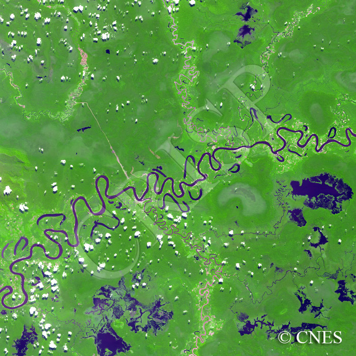
Note: The area of coverage in this SPOT-5 image is approximately 40 km x 40 km.
The reduced resolution image on display has undergone compression and so does not represent the true resolution of the original satellite image.
The Kapuas meanders northeast to southwest across the swamplands of west Kalimantan. Numerous oxbow lakes and scroll bars demonstrate the mobility of the Kapuas on this flat plain. All stages of meander cutoffs are displayed from an incipient contact between the two arms of a meander to a completely separated oxbow lake in the process of drying up. The mouths of the tributaries are elongated downstream near their junction with the Kapuas because of its wandering. The tributaries themselves tend to meander and shed oxbow lakes as, in the middle of the image, they approach the flat plain through which the Kapuas flows. The longer tributaries that originate outside the image carry considerable sediment, as indicated by the reddish-brown colour of their water. As they approach the Kapuas, they are joined by sediment-free small streams draining wetlands and small lakes. As a result of this dilution, the colour of the tributaries changes from reddish-brown to black by the time they flow into the Kapuas.