Mount Semeru, East Java, Indonesia
26 September 2004
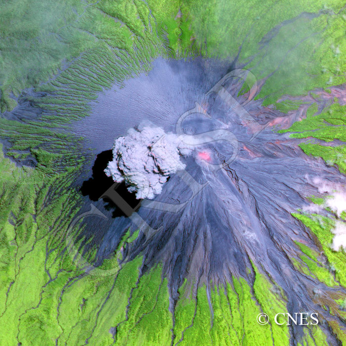
Note: The area of coverage in this SPOT-5 image is approximately 5.505 km x 5.500 km.
The reduced resolution image on display has undergone compression and so does not represent the true resolution of the original satellite image.
Mount Semeru, at 3676 m the highest volcano in Java, has been active since 1967, alternating pyroclastic explosions with minor extrusions of lava and ash emission. It is also notorious for rainfall-related mudflows. One in May 1981 killed more than 250 people. Two large pyroclastic flows occurred in 2002. The image shows glowing magma inside the crater and small extrusions of molten rock at various places on the northeastern side of the volcano. The large plume of steam, degassed from the volcano, is drifting west in the ambient wind. The upper slopes of Mount Semuru are covered with erupted pyroclastic material; the lower slopes are covered by vegetation, interrupted by radiating valleys that are filled with past lahar deposits. A very large pyroclastic flow, its deposits later modified by lahars, flowed out of the crater towards the southeast. The sidewalls show layered deposits from a sequence of eruptions.