Optical remote sensing always encounters the problem of cloud covers, especially over the tropical areas. However, if multiple images acquired at different time over a given region are available, then it is possible to generate a reasonably cloud-free composite scene by mosaicking the cloud-free areas in the set of images. CRISP has developed an operational software package for generating such cloud-free mosaics from
multispectral images acquired by satellites such as the SPOT satellites. The algorithm makes use of a combination techniques in image processing and analysis to generate a cloud-free mosaic with minimal input from a human operator.
Sample Input Cloudy Images
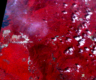
The four SPOT images of a location shown below were acquire at different time. These images suffer from various degrees of cloudiness.
|
 |
 |
| A cloudy SPOT image acquired on 1996 June 24 |
A cloudy SPOT image acquired on 1996 November 01 |
 |
 |
| A SPOT image acquired on 1997 January 25. It is
generally clear on the left side, but note the thin clouds covering the
top left quarter of the image |
A cloudy SPOT image acquired on 1997 August 09 |
Sample Output Cloud-Free Image
The mosaic produced by the software shows no trace of clouds or cloud-shadows. Even the thin clouds present in one of the input image is removed.

|
A Cloud-Free Mosaic of the above four SPOT scenes.
|
How It Is Done

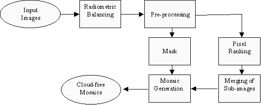
The Schematic of the Cloud-Free Mosaic Algorithm
The algorithm used in generating the cloud-free mosaic involves the following steps:
- Input Images - The inputs to the system are multispectral images of the same region acquired within a specified time interval. The images are also co-registered before being fed into the system.
- Radiometric Balancing - The radiometric balancing procedure automatically corrects for differences in sensor gains, solar incidence angles and solar flux between the acquired scenes.
- Pre-processing - The pre-processing procedure fine tunes the radiometric intensity in selected areas of interest to compensate for the differences in intensity caused mainly by atmospheric effects.
- Pixel Ranking - The pixel ranking procedure uses the pixel intensity and some suitably chosen band ratios to rank the pixels in order of "cloudiness" and "shadowiness" according to predefined ranking criteria. The ranking procedure automatically takes into consideration the effects due to different land cover types such as vegetation, buildings, water and others.
- Merging of Sub-Images - In this procedure, the pixel ranks are used to merge the input images together. Special care is taken to avoid sudden spatial discontinuities in the vegetation area.
- Selection and Masking of the Base Image -
In order to get better visual effects it is desirable to have as many pixels as possible in the neighbourhood of a given location to come from the same scene. In this procedure, the image which was deemed to have the lowest cloud coverage by visual inspection is chosen to be the base image. Cloud and shadow thresholds are then applied to this base image to delineate the cloud shadows and the cloud covered areas. In the next step of mosaic generation, only the delineated cloud and shadow areas will be replaced with pixels from the merged image generated from the previous step.
- Mosaic Generation -
The final mosaic is composed from the merged images and the base image. These images are geo-referenced to a base map using control points. The mosaic generation transforms the coordinates of the pixels in the merged images and the base image into map coordinates and put the pixels onto the final image map.
|
|
|


