 |
 |
 SRTM - Shuttle Radar Topography Mission
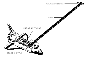
 The SRTM - Shuttle Radar Topography Mission is an international project of the National Aeronautics and Space Administration (NASA), National Imagery and Mapping Agency (NIMA) of the United States, the German Aerospace Center (DLR) and the Italian Space Agency (ASI). Its objective is to obtain the most complete high-resolution digital topographic database of the Earth. The SRTM payload onboard the Space Shuttle Endeavour was launched on February 11, 2000. The mission lasted 11 days. The radar instruments are similar to those deployed for the SIR-C/X-SAR mission. To acquire topographic (elevation) data, the SRTM payload was outfitted with two synthetic aperture radar antennas. One antenna was located in the Shuttle's payload bay, the other on the end of a 60 meter mast that extended from the payload bay once the Shuttle was in space. SRTM made use of a technique called radar interferometry to acquire topographic information. In radar interferometry, two radar images are taken from slightly different locations. Differences between these images allow for the calculation of surface elevation, or change. In SRTM, the two radar images required for performing interferometry are acquired simultaneously by the two antennas. SRTM was launched into an orbit with an altitude of 233 km (nominal), and an inclination of 57 degrees. This allowed most the Earth's land surface that lies between 60 degrees north and 56 degrees south latitude to be covered by the SRTM radars. This is about 80 percent of the Earth's land mass. There are two types of antenna panels: C-Band and X-Band. The C-band radar data processed at the Jet Propulsion Laboratory (JPL) provide near global digital elevation models (DEMs). Higher resolution DEMs (but not with global coverage) are produced from the X-Band radar data, processed and distributed by the German Aerospace Center, DLR. Processing of the C-Band data is expected to take two years. The C-band data will be distributed through the United States Geological Survey's EROS Data Center. The final archive is expected to be delivered to USGS in October 2002. Ultimately, the final released SRTM DEM will be at 30 meters for the U.S. and at 90 meters for the rest of the world, although NASA and NIMA are still discussing these issues.
Link to: SRTM Home Page (http://www.jpl.nasa.gov/srtm/) at JPL, NASA  Back to Main Index Back to Main Index
|