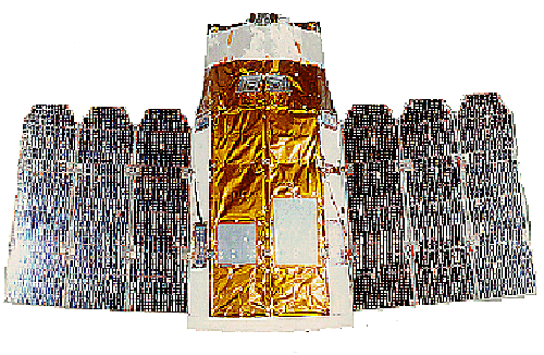
Launched on 6 December 2000, EROS-A1 is the first of a planned
series of commercial high resolution remote sensing satellites
from ImageSat International, an international company formed in
1997. Three main shareholders of ImagSat
International are, Israel Aircraft Industries, Ltd. (Israel),
Electro Optics Industries, Ltd. (Israel), and Core Software Technology
(USA). EROS-A1 collects black and white (panchromatic)
images at 1.8m resolution.The nominal swath width is 12.5km. The light weight (260 kg) and agile
design of the satellite allows it turn up to 45 degrees in any
direction as they orbit, providing the power to take shots of
many different areas during the same pass. The satellites' agile
ability also allows for stereo imaging during the same orbit. The follow-on satellite, EROS-B will have improved resolution
of 0.82m and swath width of 16km.
EROS-A1 Orbit
| Type | Sun-Synchronous |
| Altitude |
475-491 km |
| Inclination |
97.3 deg |
| Descending node crossing time |
9:45 am local solar time |
| Period |
94 min |
Image Type
|
Basic Scene
|
12.6 x 12.6 km
|
|
Mosaic
|
25.2 x 25.2 km
|
|
Monostrips,
up to 30 deg from nadir
|
Up to 120 x 12.6 km
|
|
Monostrips,
up to 43 deg from nadir
|
Up to 217 x 12.6 km
|
|
Stereo
Monostrips
|
Up to 44 x 12.6 km
|
|
Stereo
Scenes
|
12.6 x 12.6 km
|
Sensor Characteristics
|
Sensor Type
|
CCD
|
|
Ground
Sampling Distance
|
1.8m
|
|
Scanning
|
Asynchronous
(up to 750 lines/sec)
|
|
Spectral
Band
|
0.5 - 0.9
micrometers
|
|
Radiometric
Digitization
|
11 bits
|
|
Pixels-in-line
|
7,800
|
Link to: Space Imaging Web Page.
 Go to Main Index Go to Main Index
|


 EROS-A1, ISRAEL