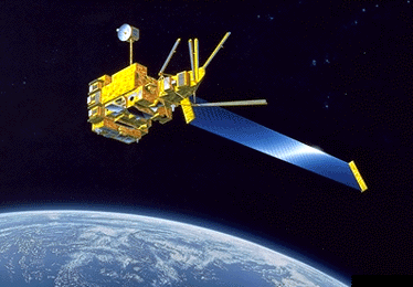
ADEOS (also known as "Midori" in Japanese) is a remote sensing satellite operated by the National Space Development Agency of Japan (NASDA) for global
observation of land, ocean and atmospheric processes. ADEOS was launched on 17 August 1996. ADEOS was expected to acquire data on worldwide environmental changes such as the greenhouse effect, ozone layer depletion, deforestation and abnormal climactic conditions. The main imaging instruments on ADEOS are the high resolution AVNIR and the low resolution OCTS.
The satellite encountered several problems after launch. The satellite's mission ended in June 1997, after 10 months in operation, due to a breakdown of the solar panel array.
ADEOS is to be followed by ADEOS-2, initially scheduled to be launched in November 2001. The launch has since been postponed to a later date in 2002.
ADEOS-1 Orbit
| Type | Sun-Synchronous |
| Altitude | 797 km |
| Period | 101 min |
| Repeat Cycle | 41 days |
ADEOS-1 Sensors
- OCTS (Ocean Colour and Temperature Sensor): OCTS
is an optical radiometer developed by NASDA for global measurement
of ocean colour and sea surface temperature. It has 8 bands
in the visible and near-infrared region and 4 bands in the thermal
region. OCTS data can be used for determination of the ocean
primary production and carbon cycle and for getting information
on ocean conditions for fishery and environmental monitoring.
- AVNIR (Advanced Visible and Near Infrared Radiometer): AVNIR developed
by NASDA is a high spatial resolution optical sensor for observing
land and coastal zones in the visible and near-infrared regions.
It has 4 spectral bands with a 16 m spatial resolution and 1
panchromatic band with an 8 m spatial resolution.
- NSCAT (NASA Scatterometer): NSCAT is an active radar instrument developed
by NASA's Jet Propulsion Laboratory (JPL), USA, for measurement
of global wind speeds and directions over the ice-free oceans.
It uses an array of antennas that radiate microwave pulses at
Ku band (14 GHz frequency). Study using NSCAT data are expected
to lead to improve methods of global weather forecasting and
modeling.
- TOMS (Total Ozone Mapping Spectrometer): TOMS is developed by NASA's
Goddard Space Flight Center (GSFC) for measurement of total
ozone spatial distribution.
- POLDER (Polarization and Directionality of the Earth's Reflectances):
POLDER is developed by the French Space Agency (CNES) for observation
of the polarisation, directional and spectral characteristics
of the solar light reflected by aerosols, clouds, oceans and
land surfaces.
- IMG (Interferometric Monitor for Greenhouse Gases)
- ILAS (Improved Limb Atmospheric Spectrometer)
- RIS (Retroreflector in Space)
ADEOS-2 Sensors
- GLI (Global Imager): GLI is an optical sensor developed
by NASDA, Japan. It observes the reflected solar radiation from
the Earth's surface, including land, oceans and clouds and/or
infrared radiation with a multi-channel system for measuring
the biological content, such as chlorophyll, organic substance,
and vegetation index as well as temperature, snow and ice, and
cloud distribution. These data will be used for understanding
the global circulation of carbon and climate changes. GLI has
36 bands in the visible-NIR, SWIR and thermal IR. The VNIR and
SWIR bands have two resolution modes: 250 m and 1 km, while
the thermal IR has a resolution of 1 km. GLI is an advanced
version of the Ocean Color and Temperature
Scanner (OCTS) on-board ADEOS.
- AMSR (Advanced Microwave Scanning Radiometer): AMSR is a passive microwave
radiometer. It detects microwave emissions from the Earth's
surface and atmosphere. Various geophysical parameters, particularly
those related to water, can be estimated from AMSR data. In
addition to the conventional parameters, such as water vapor,
precipitation, and sea surface wind speed, novel geophysical
parameters, including sea surface temperature and soil moisture,
are expected to be retrieved by using new frequency channels.
AMSR is an eight-frequency, total-power microwave radiometer
with dual polarization (except two vertical channels in the
50GHz band). Conical scanning is employed to observe the Earth's
surface with a constant incidence angle. It carries an offset-parabolic
antenna with a diameter of 2m, the largest space-borne microwave
radiometer antenna of its kind.
- SeaWinds (Sea Winds Scatterometer):
NASA's SeaWinds Scatterometer is an active microwave scatterometer operating at 13.4 GHz microwave frequency. It is the continuation of NSCAT on board the ADEOS satelite. It will provide high accuracy wind speed and direction measurements over at least 90% of the ice-free global oceans every 2 days. SeaWinds will provide a continuing set of long term wind data for studies of ocean circulation, climate, air-sea interaction and weather forecasting.
- POLDER (Polarization and Directionality of the Earth's Reflectances)
- ILAS-2
 Back to Main Index Back to Main Index
|


 ADEOS (Advanced Earth Observing Satellite), Japan