|
The lowland Mekong Basin in Cambodia and Vietnam is regularly affected by floods during the rainy season. The flood usually peaks in October and recedes in December. In 2000, many places have been affected by severe floods in early August. This flood has been reported to be the most severe in 40 years.
The Centre for Remote Imaging, Sensing and Processing (CRISP) at the National University of Singapore has acquired satellite images of this extraordinary flood event in the Mekong Basin. The images were acquired by the French SPOT satellites, with a resolution of 20 m. The flood area is estimated to affect over 30,000 square kilometers, more than 50 times the size of Singapore. |
Space View of the Flood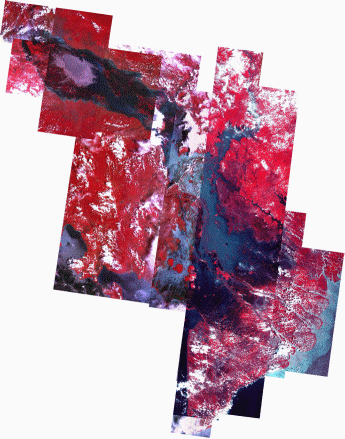
This mosaic of the lowland Mekong Basin in Cambodia and Vietnam has been prepared from several September 2000 SPOT scenes. The flood boundaries therefore are not of the same day but the mosaic does illustrate and record the wide extent of this extraordinary flooding. The northern boundary of the mosaic is approximately at the latitude of 14° N, and about 700 km of the Mekong is shown from Stung Treng (Cambodia) to the sea. The blue in the mosaic is the area under water; the higher ground that has not been flooded is in red. The various shades of blue reflect water depth and also the varying amount of sediment load. The higher levees along the river and the embankments marking canal banks show up as thin red lines. The water has inundated the lower areas and in the southwest has reached the sea beyond the corner of the Elephant Hills. The part of the Mekong delta near the sea has not been flooded which could be due to both non-arrival of the floodwater at the time the images were taken and the slightly higher elevation of the delta face next to the sea. The major distributary of the Mekong, the Bassac, also flooded, runs parallel to the Mekong and slightly to its west. Where the Bassac leaves the main river, the Tonlé Sap River comes into the Mekong from the northwest, draining the lake of Tonlé Sap to the Mekong. Its direction of flow is reversed during the rainy season and water flows back to the lake. This year is an extreme case with the entire Tonlé Sap valley being under water and the lake acquiring huge dimensions. Submerged vegetation can be seen around the lake. |
Flood Map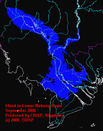
The flood extent map was prepared by delineating the flooded area in the SPOT mosaic. The dark blue regions are inundated. It covers an area over 40,000 square kilometers. The normal wet season area of the Great Lake (Tonle Sap) in Cambodia is about 10,000 square kilometers. So the flood this year has affected over 30,000 square kilometers, which is more than 50 times the size of Singapore. Most of the inundated lowland, especially the delta, is well populated and this is fertile cropland. Floods of this size also transport a huge amount of sediment from the channel and valley flat to the sea. Floods of this size happen due to a combination of meteorological events but one wonders whether land degradation in the Mekong Basin has accentuated the level and effect of the flood. |