|
CRISP ground station has been actively acquiring ERS-1/2 data since March 1996.
To date, complete ERS data covering the landmass of Southeast Asia have been acquired. As full scene processing requires a lot of
computing resources, current practice is to process only the user requested data. In CRISP, a ERS quicklook processor has
been developed. The quicklook processor processes the ERS data into reduced resolution imagery (resolution of 100-150m).
All the ERS 1/2 data in CRISP's archive have been processed to this quicklook images. An attempt to mosaick a complete coverage of these quicklook images over the landmass of Southeast Asia has been completed.
About 1,500 scenes were used in this exercise. To accomplish this exercise in an efficient and cost effective manner, a
highly automated software was developed to compose the mosaic.
Extracts from the ERS SAR mosaic of Southeast Asia are shown below.
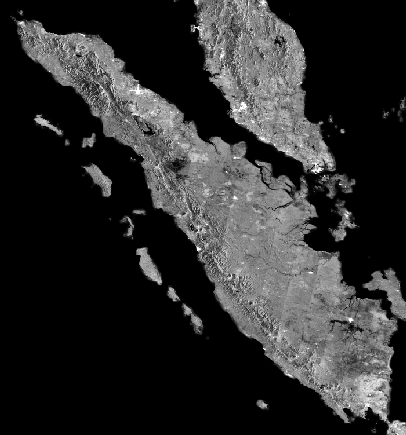
ERS SAR Mosaic of Sumatra, Peninsular Malaysia and SingaporeThe image below is a large area mosaic made up of 26 passes (more than 600scenes) of ERS SAR images. It shows the complete Sumatra island of Indonesiawith Peninsular Malaysia and Singapore to its north.This mosaic image beautifully illustrates the utility of radar in understanding the basic geological features in an area which is normally under heavy cloud cover and vegetation. The major fault system on the island, the Semangko Fault, is seen trending the entire length of Sumatra. Most volcanoes are located on or very near this fault system including the large depression of Toba towards the northwest. The Semangko Fault system and its associated volcanoes have given rise to the Barisan Mountains which form the backbone of Sumatra.

© ESA 1996 . Sumatra, Indonesia . ERS-SAR Mosaic The Semangko Fault is of strike-slip variety and the associated convergent plate margin subduction lies to the southwest below the Indian Ocean. The islands off the west coast of Sumatra are over the fore-arc basin of this subduction zone. Eastward from the Barisan Mountains lies a rolling landscape which terminates at a very wide swampy coastal plain next to the Malacca Strait. Lake Toba is a complex and very large tectonic-volcanic depression. The past volcanoes of the area erupted several times releasing huge quantities of ash which has deposited a special type of rock called ignimbrite in this area. The eruptions were so large that Toba ash has been found as far west as Sri Lanka and India. Violent eruptions and tectonic collapses created the huge depression which later was filled up with water to form Lake Toba. One of the eruptions which took place about 73 000 years ago was gigantic. In this super-eruption an estimated 2800 km3 of material was released. In contrast, Mount St. Helens in 1980 and Pinatubo in 1991 ejected 0.35 km3 and 5 km3 of material respectively.
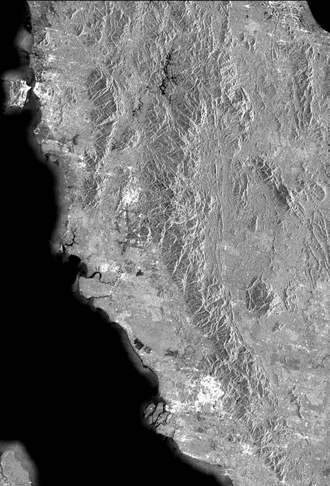
ERS SAR Mosaic of Northern Peninsular Malaysia
The major characteristics of the geology of the western part of the Malay Peninsula are illustrated by this radar image. The north-south running granitic Main Range and the other granitic hills (such as on the island of Penang) stand out clearly along with various structural lineaments. The flat western coastal plain with the lower courses of the meandering Perak and other rivers is clearly visible. Such a radar image not only sees through clouds but also highlights some of the geological characteristics and relief features. | |||||
| Copyright © CRISP, 2001 |


